
Finding Kirkwood Residents by Street
An address-first search begins with a parcel, not a person list. The city GIS service locates the parcel and its geometry; the county property search identifies the current account and tax-year result; the Recorder index follows recorded instruments. Historical directories can then provide dated household leads. This order is useful because it keeps the search focused on the same physical property while clearly separating an account holder, a mailing recipient, a deed party, a permit applicant, and a directory occupant.
Street records do not establish every occupant at an address. A current property name can be a trust, estate, or remote owner. A voter source is controlled by Missouri rules. An older directory may list only a head of household. Record the source date and field label before comparing results along a Kirkwood street.
- Enter the complete address in the county property search and retain the property number, tax year, result name, and address field shown.
- Locate the same point in the Kirkwood parcel service, then record the parcel polygon, address annotation, and zoning layer.
- For a recorded ownership trail, search the Recorder by grantor or grantee and date, then save the instrument number or book and page.
- Use the City of Kirkwood permit portal by project address when the question concerns work, inspections, a plan, or a code case.
- For a past household, select a directory year and check a reverse directory or the alphabetical volume around the likely street entry.
Kirkwood Parcel Address Layers
The official Kirkwood zoning and parcels MapServer is a service endpoint with Anno Address, Parcel, and Zoning layers. Its query, identify, and export-map functions support a documented parcel check. After identifying a subject parcel, compare its touching polygons rather than drawing a loose radius. A corner lot, alley, rear parcel, different ZIP, or municipal line can make nearby geometry misleading.
Kirkwood's GIS zoning and parcel service displays the official layer inventory and query capability used for an address-based check.
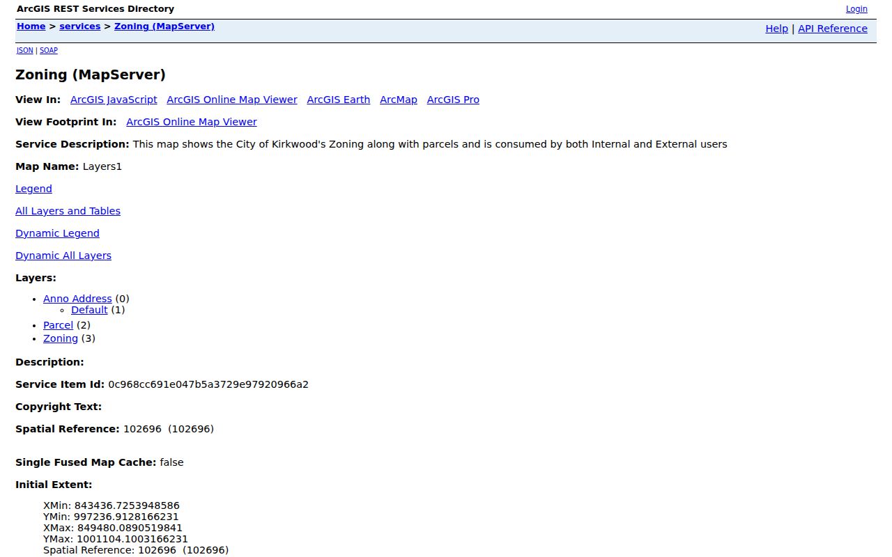
The image shows why a parcel-led street directory starts with layers and geometry. It does not turn a parcel map into an occupancy list.
Kirkwood Property Result Fields
The St. Louis County Property Tax Inquiry uses one search prompt, Property Number, Owner Name, or Address. Select All, Real Estate, or Personal Property, then read the result row as a dated account snapshot. It exposes year, property number, name, address, and type; the results paginate and can be exported to CSV. That is enough to anchor a street search to a specific parcel account before moving to a deed or directory.
| Field or control | Form | Street-directory use |
|---|---|---|
| Property Number, Owner Name, or Address | One text search | Use the complete address or account holder to reach a current property result. |
| Record type | Optional selection | Choose All, Real Estate, or Personal Property when a broad result needs narrowing. |
| Year, number, name, address, type | Result fields | Save the displayed date and labels rather than treating a result as timeless. |
| Pagination and CSV export | Result controls | Use the export as a research record, not as a reason to create a public name list. |
County library guidance says the related IAS search can use locator number, address, name, or subdivision and may include a property sketch, aerial photo, year built, and deed-index list. The live historical cutoff was not located, so those fields should be recorded only as displayed for the parcel at hand.
Note: A property account name identifies the account relationship, while a separate mailing or taxing field can point somewhere other than the Kirkwood parcel.
Kirkwood Project Address Records
Kirkwood's Tyler EnerGov Public Portal adds a municipal address layer. Its public categories are permits, plans, inspections, code cases, requests, and licenses. Search public records by permit number or project address. Applying or managing personal work requires an account and MFA, but the public search may work without a login.
A project address can explain work on a structure or a municipal process. It cannot by itself prove that an applicant, contractor, or architect lived at the address. The historical retention window and exact result fields were not verified in the reviewed static source, so keep the displayed record date and category with any result.
Kirkwood Street Deed Trail
Recorder research follows the legal instrument trail, not a list of occupants. The St. Louis County deed-search guidance identifies grantor, grantee, date, document number, affected book and page, book and page, pages, locator or lien number, instrument type, and legal description. Begin with party and date. A locator number is optional and can return an incomplete result set.
When the index finds the transfer, retain the parties, recording date, legal description, and book/page or document number. Images may require a public terminal or the Recorder copy-order form. A recorded deed is not a title opinion and does not show who occupied a house on the street.
Kirkwood Street Records by Address
Address-keyed sources overlap, but each one answers a narrower question. The parcel map establishes the land unit. The tax search names an account and current result year. A deed index names recorded parties. EnerGov can show an address-linked municipal process. A directory supplies a dated resident or business entry. Moving through these sources in sequence creates a careful Kirkwood street directory trail without claiming that any one of them lists every household member.
| Record Set | Keeper | What It Shows | Access |
|---|---|---|---|
| Property tax account | St. Louis County | Current year, account name, property number, address, type | Public web search |
| Parcel and zoning service | City of Kirkwood | Address annotation, parcel geometry, zoning | MapServer query and identify |
| Recorded instruments | County Recorder | Grantor, grantee, date, instrument, legal description | Index plus terminal or copy request |
| Election records | State and County Board of Elections | Controlled registration confirmation or selected list fields | Statutory and form-specific access |
| Permits and code records | Kirkwood Building Division | Project-address activity and category | EnerGov public search |
The parcel identifier and situs address carry the search from map to property account. The recorded legal description then gives a stronger historical key than an address alone. Missouri voter records are a separate controlled source, not a field that should be merged into a public street list.
Kirkwood Reverse Street Volumes
For a past address, the St. Louis County Library's city-directory collection supplies the household layer that deeds cannot. Its digital workflow is to choose a directory year, search a surname or portion of an address, and browse the alphabetical section. Reverse or criss-cross directories, when a volume has them, arrange entries by street and house number. Pair that street result with the alphabetical entry and preserve the volume year and page or image.
The verified county run includes volumes from 1893 to 1979 with meaningful gaps. The 1910 Directory of the City of Kirkwood is a separate Missouri Historical Society index with 2,622 records and address fields. The historical collection detail belongs on the Kirkwood city directories page; here it is the dated street check after the parcel and deed steps.
Kirkwood Street Map Evidence
Older addresses require proof, not a guessed conversion. Research identifies the Pitzman atlas of 1878, the 1909 St. Louis County plat book, and a verified 1926 Sanborn map citation for Kirkwood. Compare the directory spelling and number, a deed legal description, plat lot or block, parcel polygon, and a Sanborn cross street. A matching lot is stronger evidence than a similar street name.
No official general street-renumbering schedule was found. Kirkwood began as a railroad community in 1853, incorporated in 1865, and Meacham Park was annexed in 1991. These dates can change a record's jurisdiction label, but they do not prove an old and current street number are equivalent. The city's nine historic districts add useful period context for a property, not proof of a resident.
Note: Mark an old-address match as unresolved until a dated directory, plat, ordinance, or legal description connects the two forms.
Kirkwood Missing Record Routes
A missing web result needs the right custodian. The Recorder offers public research and a deed-copy request. The City Clerk receives requests for older municipal records, including minutes beyond the city's online posting period. SLCL and the Kirkwood Historical Society cover directories, local histories, and physical collections. For county material outside a public interface, submit a specific request through the county records portal under the Missouri Sunshine Law.
The law requires a response as soon as possible, generally no later than the end of the third business day, with an explanation and earliest response time if more time is needed. It does not require an office to create a new record or bypass a closure rule. Name the department, record type, date range, street address, and parcel or instrument number where known.
For material beyond the county counter, the Missouri State Archives maintains a research room, online request route, county and municipal records database, and statewide research contacts. The Kirkwood Historical Society offers research sessions by reservation at Mudd's Grove. These are useful fallbacks when a street appears in a local-history record, map, or physical collection rather than a modern portal. State, library, city, and county results should remain labeled by the custodian that supplied them.
Kirkwood Street Directory Limits
A street directory can identify a parcel, a current tax account, recorded parties, address-linked city activity, and dated directory entries. It cannot make a complete household list. Mailing and taxing addresses can differ from the situs address. A directory name may be historical, a permit participant may have a professional role, and a deed party may never have occupied the property. Safe at Home and other protected-address rules require special care.
Missouri voter data is controlled by statute and the state confirmation form requires identity inputs. Public court material can be redacted or confidential. Utilities, delivery services, and similar private-account records are not substitutes for a lawful record trail. When records disagree, describe the disagreement instead of forcing a conclusion about the people on a Kirkwood street.
For a block-level election question, the St. Louis County Board of Elections uses a separate request form rather than a general street browse. The form can request active-voter lists or selected history and district output, with fields such as address components, ZIP, precinct, registration date, and election date. Its default list contains active voters, and the form applies its own fees and use restrictions. That controlled route should stay separate from a property-account or deed search.
Keep an access date beside every online result. Parcel layers, directory scans, court access, and municipal portals can change without changing the underlying historical fact being investigated.
- Parcel
- The mapped land unit that links a street address to property and legal records.
- Situs address
- The physical location of the parcel, distinct from a tax-notice or mailing destination.
- Plat
- A recorded map that can identify a lot, block, or subdivision when street labels have changed.
- Criss-cross directory
- A historical volume arranged by street and house number, useful only for its specific publication year.
Note: Label a result as an account, instrument, permit, or dated directory entry so a reader can see exactly what the Kirkwood street record supports.
Lawful use. Use Kirkwood street records for family history, property context, civic research, and personal curiosity. Never use an address trail to stalk, harass, intimidate, or harm another person.