
Kirkwood ZIP Code Directory Coverage
The ZIP code directory for Kirkwood should be read as a postal association, not a drawn municipal border. Official Census profile material associates the city with 63122, 63127, and 63131. Each has a different relationship to Kirkwood and nearby places. The best first check is the USPS ZIP Code Lookup, followed by the address and parcel record for the actual location. That sequence keeps a postal last line from being mistaken for a city or county jurisdiction.
| ZIP code | Kirkwood-area association | Postal lead | Careful reading |
|---|---|---|---|
| 63122 | Core Kirkwood association | Kirkwood Post Office | The postal last line can say Saint Louis and the ZIP can extend beyond a city boundary. |
| 63127 | Broader Kirkwood and Meacham Park-area geography | Use USPS by address | No dedicated 63127 facility was located in the reviewed official results. |
| 63131 | Western and northwestern Kirkwood-area addresses | Des Peres Post Office | It also serves nearby West County places, including Des Peres associations. |
USPS delivery geography, a Census ZIP Code Tabulation Area, a parcel boundary, and a Kirkwood city boundary answer different questions. The ZIP code directory can narrow an address, but the full street address must decide the result. Note: Retain the date of a USPS result because delivery conventions can change without changing a residence.
Kirkwood ZIP Code Postal Last Lines
One useful local lesson is the official Kirkwood Post Office listing. Its location is 222 S Taylor Avenue, yet its official last line is Saint Louis, MO 63122-9998. That does not make the post office a Saint Louis city facility or erase its Kirkwood identity. It shows why a mailing line should be copied as USPS returns it while a municipal field remains tied to the city record or parcel.
The official post-office view is shown here.
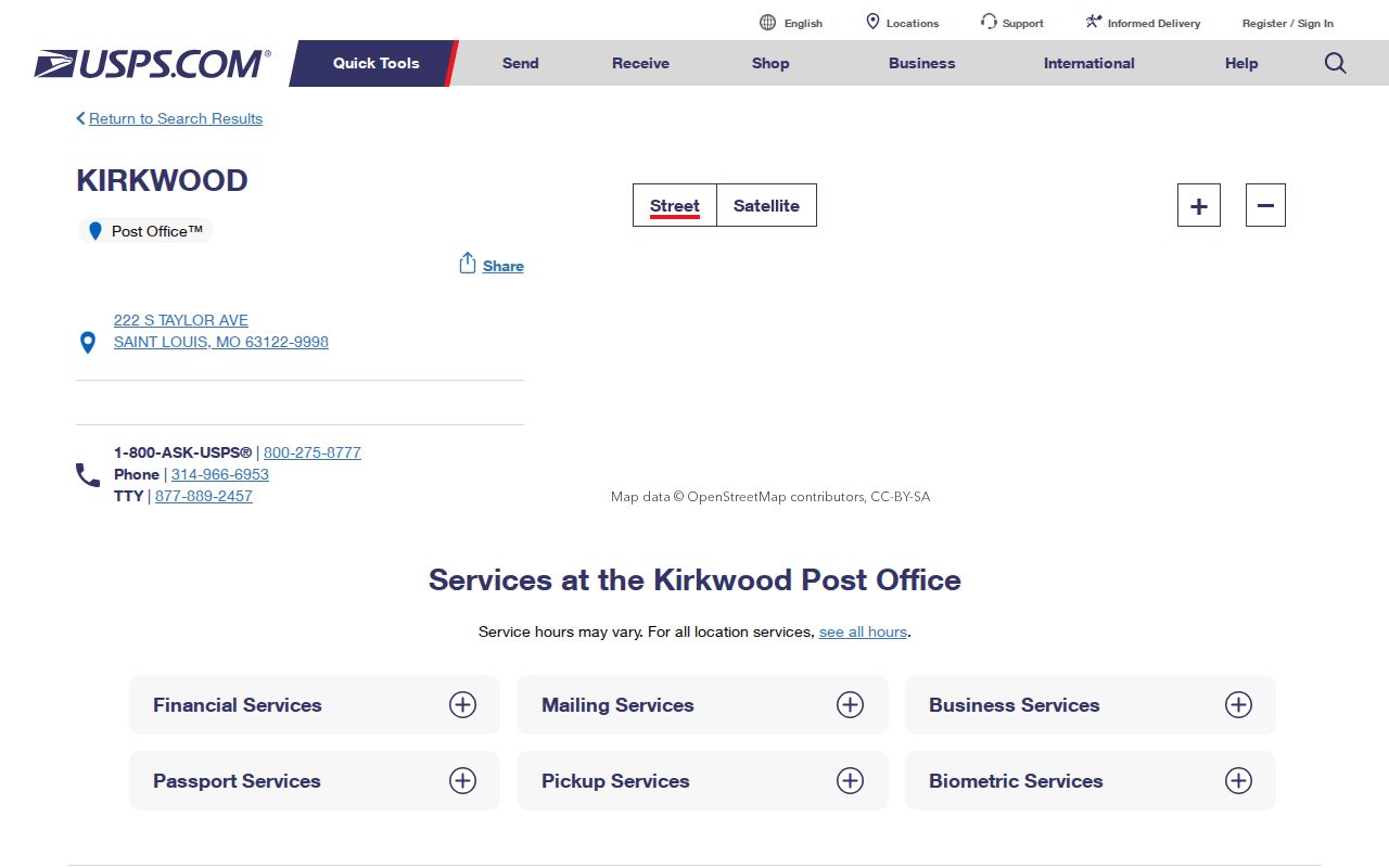
That listing gives the core 63122 postal anchor, while the other Kirkwood-associated ZIPs still need an address-level verification. This is a common ZIP code myth: a familiar place name, a postal last line, and the incorporated-city line are related, but they are not interchangeable.
Kirkwood ZIP Code Lookup Modes
The USPS tool has three separate modes, and choosing the right one avoids a broad result being used as proof about a single address. By Address is the method for a known house or apartment. By City and State produces a postal-place result. Cities by ZIP reverses the question and reports associated place names. None of the modes confirms that a particular person or company is at an address.
| USPS mode | Fields captured in the official interface | Best Kirkwood use |
|---|---|---|
| By Address | Street address is required; company, apartment, city, state, and ZIP have labeled fields. | Standardize a complete local address before opening property records. |
| By City & State | City and state are required. | Check postal associations without treating them as city limits. |
| Cities by ZIP | A ZIP code is required. | See which postal-place names attach to a known ZIP. |
For an old envelope or directory entry, compare the spelling and date before standardizing it. The postal form reports current addressing data, so it is not a substitute for a dated directory, plat, or deed description.
Find Kirkwood Records by ZIP Code
A ZIP code can organize a search, but the reviewed county property and GIS interfaces do not expose a verified ZIP-only filter. Use the confirmed delivery address to reach the next official record. The St. Louis County tax inquiry accepts a property number, owner name, or address and has real-estate and personal-property filters. Kirkwood GIS is useful for a mapped address and parcel, while county election material makes ZIP available through controlled list output rather than an open self-service directory.
- Run the full address through the USPS lookup and preserve its current format.
- Enter the confirmed address in the St. Louis County Property Tax Inquiry to find the relevant property account.
- Compare that result with the Kirkwood GIS parcel and zoning service, recording the displayed parcel and zoning layers.
- When a search moves from a ZIP area to a named road, use the Kirkwood street directory for the fuller address-by-address record trail.
The property record may show a taxing or mailing address separate from the situs address. A situs address identifies the parcel; a mailing address identifies where tax correspondence goes. Neither field alone proves that every person connected with the address currently lives there.
Kirkwood ZIP Code Filter Options
Official tools handle ZIP information in different ways. USPS has a direct ZIP field and city-by-ZIP mode. The Missouri State Highway Patrol registry permits ZIP and address-radius criteria, while Missouri professional registration can sort downloadable active listings by ZIP after a profession is selected. Those are separate record types and should not be blended into a claim about a household. The tax inquiry accepts an address string, but the reviewed interface did not show a dedicated ZIP filter.
| Official source | How ZIP appears | Boundary on the result |
|---|---|---|
| USPS ZIP Lookup | Direct address and cities-by-ZIP queries | Reports postal addressing, not municipal residence. |
| County tax inquiry | Part of an address query or result | No dedicated ZIP-only filter documented. |
| County election list request | An available output field | Organized by list, district, or history request, with controlled access. |
| Kirkwood GIS | Mapped address and parcel workflow | No ZIP search field exposed in the static service description. |
The paid Board of Elections Election Information Search Form can request ZIP among its output fields, alongside district and address components. It is not an unrestricted web directory, and its form says active voters are included by default. Note: Use the record type and date shown by the custodian rather than trying to build a ZIP-wide list of people.
Kirkwood ZIP Code and Parcel Layers
ZIP associations become more reliable when compared with the parcel itself. The Kirkwood MapServer exposes address annotations, parcels, and zoning layers, with query, identify, and export operations. Record the displayed situs address, parcel or locator number, parcel outline, city or township, zoning, owner field if present, any separately labeled mailing field, and the access date. The service description does not provide a friendly ZIP search button, so a map result should be described as an address-and-parcel check.
County GIS is the broader mapping entry point, but available layers can change by service. A parcel polygon is not the same thing as a postal boundary. It can also sit near another ZIP, city, or neighborhood line. For that reason, compare the postal result and the parcel result instead of forcing both to use one place label.
Kirkwood ZIP Code Census Context
The Census treats ZIP Code Tabulation Areas as statistical approximations. Its Kirkwood profile material associates the city with 63122, 63127, and 63131, but a ZCTA does not redraw Kirkwood’s legal edge. The Census QuickFacts profile reports city-scale measures, including a 2020 population of 29,461 and a 2025 estimate of 29,331. Those are context for the city, not a count for any ZIP or block.
QuickFacts also reports 9.18 square miles of land and 91.2% same-house residence for 2020 to 2024. Such measures can explain why a dated address search is worthwhile, but they do not establish that a specific person remained at a particular address. Keep ZIP, city, parcel, and household evidence in separate columns when comparing sources.
Kirkwood ZIP Code Boundary Terms
A ZIP code directory needs clear terms because similar labels describe different systems. Kirkwood addresses can use a Kirkwood community name while USPS uses a Saint Louis last line. Likewise, 63131 includes nearby places and 63127 must be checked against the parcel and city boundary. No official ZIP realignment history for the Kirkwood-associated ZIPs was located in the reviewed sources, so current lookup results should be dated rather than turned into a historical boundary claim.
- ZIP code and ZIP+4
- A ZIP code directs mail to a delivery area. ZIP+4 adds a smaller delivery segment, not a city-jurisdiction label.
- PO box ZIP
- A ZIP used for post-office boxes can describe mail service without identifying a street-delivery area.
- Unique ZIP
- A ZIP assigned to a single organization or high-volume recipient; none should be assumed for Kirkwood without a USPS result.
- Carrier route
- A postal delivery sequence within an area. It is useful for mail operations, not proof of a municipal boundary.
Kirkwood ZIP Code Historical Addresses
Modern ZIP codes should not be projected backward onto older Kirkwood research. Historical directories, plats, and maps use the place name, street spelling, and jurisdiction current at the time. The 1876 separation of St. Louis City and County also means a record labeled St. Louis can need a different jurisdiction check than a modern Kirkwood address. Pair an old street entry with its year, then compare it to a current postal lookup only as a present-day reference.
The strongest historical trail may include a directory, parcel, deed, plat, 1926 Sanborn lead, census page, or local-history index. Each records a different moment. This ZIP code directory therefore points to a method: verify present delivery data first, then let dated sources describe the past without silently replacing their original place labels.
Note: A postal-city convention or a ZIP association is not evidence that someone moved between two historical records.